Glasgow’s surrounding area features an amazing variety of hiking adventures, with AllTrails.com listing over 144 trails. The Ben Lomond Mountain Path stands out as a crowd favorite, earning a stellar 4.7-star rating from 1,959 community reviews. Yet the city holds many hidden pathways waiting to be found. Nature lovers can explore more than 90 parks and gardens scattered across the city, creating a vast network of trails away from the busy center.
The best hikes near Glasgow lead to stunning natural wonders that go beyond the popular routes. Pollok Country Park reigns as Glasgow’s largest green space, covering 146 hectares of woodland and garden. The park features 11km of paved tracks and countless footpaths that make it perfect to walk and learn about nature. Adventurous hikers can head to the West Highland Way, which ranks among Scotland’s finest trails. Loch Lomond, Britain’s largest mainland lake, sits just outside the city. This piece shows you the secret paths that locals treasure – from easy routes you can reach by bus to hidden spots with views that match Scotland’s most beautiful hikes.
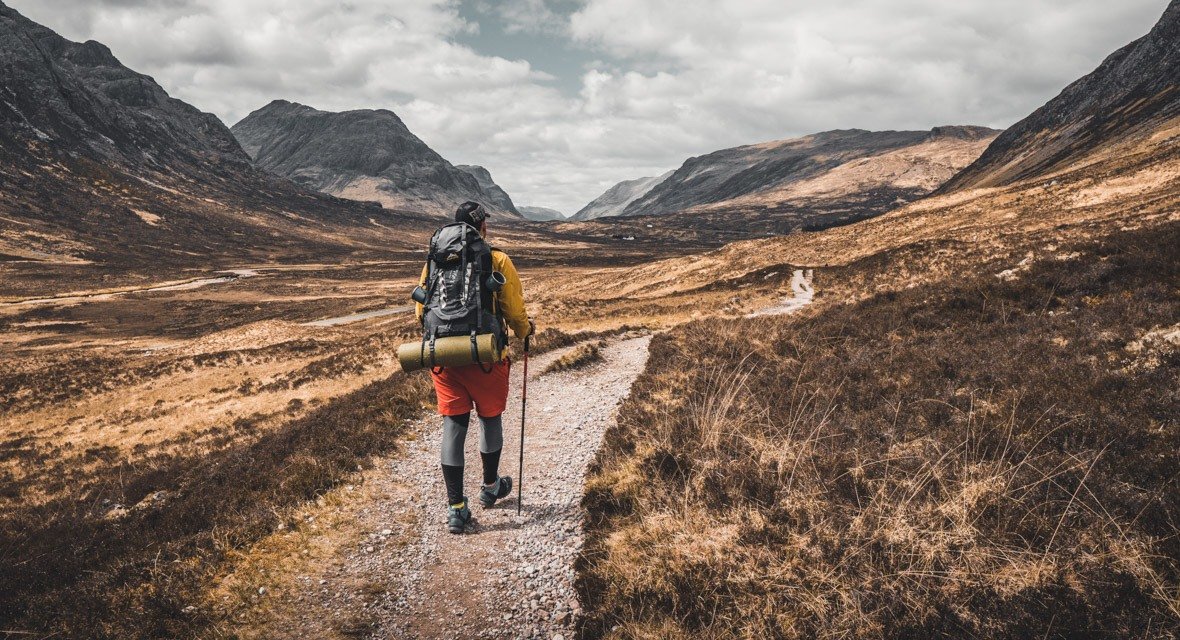
Table of Contents
- 1 Hidden Trails Within Glasgow City Limits
- 2 Secret Hikes Just Outside the City
- 3 Underrated Nature Escapes with Public Transport Access
- 4 Local Favorites with Scenic Views
- 5 Tips for Discovering More Hidden Hikes
- 6 Here are some FAQs about enjoyable hikes near Glasgow:
- 6.1 Is Glasgow good for hiking?
- 6.2 What is the most scenic hike in Scotland?
- 6.3 What is the most beautiful village near Glasgow?
- 6.4 Where to hike in Glasgow?
- 6.5 What is the most magical place in Scotland?
- 6.6 What is the famous walk in Scotland?
- 6.7 Why is Glasgow called No Mean City?
- 6.8 Which is the nicest part of Glasgow?
- 6.9 Is Loch Lomond good for hiking?
Hidden Trails Within Glasgow City Limits
Glasgow’s charm goes beyond its parks and gardens. The city hides a paradise of winding trails that only reveal themselves to adventurous souls who step away from tourist spots. Local residents love these secluded routes for weekend hikes near Glasgow that offer natural escapes within city limits.
Pollok Park’s lesser-known paths
Pollok Country Park earned its titles as “Britain’s Best Park” in 2007 and “Best Park in Europe” in 2008. This 361-acre green space has several marked trails that many regular visitors haven’t explored yet. Each path shows off the park’s natural beauty in its own way:
- The Highland Cattle Walk (1.9 miles) follows red markers through mixed woodland where you might spot the park’s famous Highland cows grazing nearby
- The Pond Walk (1.4 miles) meanders along blue markers past peaceful waters and tall pine trees
- The Burrell Walk (0.7 miles) uses yellow markers to lead visitors to the world-renowned Burrell Collection
The park also holds several unmarked “Hobbit Houses” that adventurous hikers love to discover. The Maxwell family gifted their formal gardens to Glasgow in 1966. These gardens now feature a greenhouse, exhibition allotment, flower borders, and herb garden that serve as peaceful alternatives to the main trails.
The quiet corners of Seven Lochs Wetland Park
The Seven Lochs Wetland Park sits in Glasgow’s east end as one of the city’s hidden hiking gems. This vast nature reserve has four distinct nature reserves and several reclaimed industrial areas where nature now thrives. The Seven Lochs Trail stands as the park’s highlight – a 10km (6-mile) marked path connecting Drumpellier Country Park near Coatbridge to Hogganfield Park in Glasgow.
The trail’s charm lies in its variety. Reed beds around Lochend Loch welcome wading birds while Lochwood Plantation offers peaceful woodland walks. Bishop Loch stands out with its remarkable biodiversity, earning it recognition as a Site of Special Scientific Interest. Nature photographers love this area, yet many trail sections stay quiet even during weekends.
Kelvin Walkway beyond the Botanic Gardens
The Kelvin Walkway stretches far beyond its popular section near the Botanic Gardens. Most people don’t realize it runs for 10 miles all the way to Milngavie. The path changes from a neat urban park to a peaceful riverside trail with minimal road crossings once you leave the gardens behind.
The pathway gets wilder after Dawsholm Park. You’ll find muddy patches, rough terrain, and slightly overgrown sections. This part feels surprisingly remote despite staying within city boundaries. Local families know about special spots like the “secret beach” near the West of Scotland Science Park. Here, the wider riverbank lets people get close to the water.
The trail connects with the Allander Walkway and leads straight to Milngavie, where the famous West Highland Way starts. This hidden gem offers great flexibility with numerous entry points along its length. Hikers can explore different sections without walking the entire trail.
Secret Hikes Just Outside the City
Glasgow’s outskirts hide a wealth of hiking paths that let you enjoy peaceful scenery without traveling far. These quiet trails make perfect weekend getaways for anyone who wants to explore the natural beauty around Scotland’s largest city.
Gleniffer Braes Country Park’s southern stretch holds many paths that regular visitors often miss. A 2.5-mile loop through woodlands stands out as the area’s most approachable hidden gem. This path shows off Glenburn Reservoir’s views and the peaceful Craigie Linn waterfall. The route has earned an impressive 4.3-star rating from 171 reviews on AllTrails, showing how much people love it once they find it.
Adventurous hikers can take on the Gleniffer Braes Long Circular, which spans 13.2 km and climbs 370 meters. Most people complete this trail in 3.5-4 hours. The path changes as you go, winding through woods, open hills, and farmlands where you might see Highland cattle and their calves grazing.
Getting there takes some planning. Bus 26 runs from Paisley Canal train station to Glenfield Road stops. Driving makes things easier with several parking options at Brownside Farm, Gleniffer Braes, Braehead Road, and Robertson car parks.
Duncarnock Fort from Glanderston Dam
Locals know it as “The Craigie.” Duncarnock Fort gives you one of the best short hikes near Glasgow. This 1-mile out-and-back trail climbs 183 feet and takes just 30-60 minutes. The reward? Amazing panoramic views of the countryside.
The rocky hill reaches 204 meters above sea level and holds the remains of an Iron Age fort. People of all fitness levels can enjoy this trail, making it great for families or quick nature breaks.
You can reach this spot by taking the train to Barrhead and walking about 20 minutes to Glanderston Dam via Springhill Road. A small parking area at Glanderston Dam fits 2-3 cars, but fills up fast on weekends.
Fereneze Braes summit route
Barrhead locals rate the Fereneze Braes trail as one of Glasgow’s best hikes. This 4.5-mile circular route sits east of Gleniffer Braes and mixes challenging sections with stunning views that reach the Highlands on clear days.
Most hikers finish the loop in 1.5-2 hours. The trail takes you past the summit cairn and hidden waterfalls in Killoch Glen. Highland cattle often graze peacefully on these hillsides.
The trail starts at Graham Street and Laurel Way’s corner in Barrhead, right near the train station. You’ll face some challenges along the way – boardwalks (some need fixing), kissing gates, and muddy spots after rain. The summit’s modest 256 feet height gives you surprisingly spectacular views of Glasgow and the distant hills.
New hikers should know that some trail markers and boardwalks need repairs. Downloading a route map before you go makes good sense.
Underrated Nature Escapes with Public Transport Access
Getting close to nature is easy for Glaswegians who don’t own cars. You won’t need complex planning or expensive taxi rides. The city’s public transport network connects to several amazing hiking routes that are both budget-friendly and convenient.
Clyde Walkway to Cambuslang
The Clyde Walkway’s first stage gives you a fantastic 14.5km (9-mile) path along the riverbank. Starting in central Glasgow, it stretches all the way to Cambuslang bridge. Most people complete this flat trail in about 3.5-4 hours. The route blends city and industrial views beautifully, and you’ll only climb about 25m throughout the journey.
Getting there is a breeze. Regular busses run to the Riverside Museum where the trail begins, and Partick rail station sits nearby. Once you reach Cambuslang, trains and busses run frequently back to central Glasgow.
The path has great cycling routes all the way through. Commuters on bikes will love the scenic alternative it provides. You’ll pass some amazing landmarks like the Clyde Auditorium, Glasgow Green, and the People’s Palace.
Kelvin Walkway to Milngavie
The Kelvin Walkway stretches 16.5km (10.25 miles) from Glasgow’s Clyde banks to Milngavie. This path connects the Clyde Walkway to the start of the famous West Highland Way. It’s perfect if you want to take on bigger hiking challenges.
The trail follows the River Kelvin on well-kept cyclepaths through the city. It takes a detour through Summerston before returning to the riverside. The path changes as you go – smooth footpaths and pavements lead up to Summerston, but things get rougher after that. New hikers should be ready for mud and overgrowth, particularly after crossing the A879.
Transport links are excellent here too. Busses run regularly from central Glasgow to the Riverside Museum, with Partick being your closest train station. At Milngavie, you’ll find plenty of trains and busses heading back to Glasgow.
Dams to Darnley via Priesthill station
Dams to Darnley Country Park is a green haven in Glasgow’s southside that’s surprisingly easy to reach. Priesthill & Darnley station sits just half a mile from where the walk begins. Local busses stop on Kennishead Road right by the A726 entrance if that works better for you.
This country park is a hidden treasure that will amaze you with its reservoirs, railway viaduct, and ruins. The area manages to keep its wild charm even though busy towns surround it.
Families and casual walkers will appreciate the smooth tarmac paths that work great for both strollers and bikes. The flat ground makes navigation simple. Beginners and people with limited mobility will find this an excellent starting point. The 2.2-mile Broch Burn Trail stands out as a favorite, earning 4.1 stars from 57 community reviews.
Local Favorites with Scenic Views
Local hiking enthusiasts keep a special list of spots that combine easy access with breathtaking views. These hidden gems rank among the best hikes near Glasgow and reward you with amazing experiences without demanding too much effort.
Loch Humphrey in the Kilpatrick Hills
Loch Humphrey sits peacefully in the Kilpatrick Hills and rewards hikers with stunning views of Glasgow. The challenging 16.7km out-and-back trail climbs 622m and takes about 5.5-6 hours to finish. Your journey starts at Old Kilpatrick and follows a mix of paths and paved roads through beautiful landscapes.
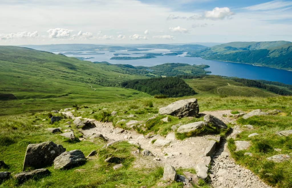
The trail’s standout feature is its amazing viewpoints. Hikers can spot the Erskine Bridge, Dumbarton Rock, and Glasgow University’s bell tower from certain spots. Duncolm, the highest peak in the Kilpatrick Hills at 401m, lets you see all the way to Loch Lomond on clear days.
The Whangie’s rock formations
The Whangie shows off one of the most striking geological features near Glasgow – a huge crack in the earth creates a narrow passage between tall rock walls. The trail runs 4.4km with a 140m climb from Queen’s View car park on the A809, making it perfect for a half-day trip.
This strange rock formation stretches over 91 meters with 12-meter-high rocks on both sides. Local tales say the devil created it by lashing his tail after witches didn’t invite him to their party. The trail gives you amazing views of Loch Lomond, the Highlands, and the Campsie Hills.
Campsie Glen waterfall trail
The charming village of Clachan of Campsie serves as the starting point for this moderate 1-mile route. You’ll climb 370ft in about 30-60 minutes. The path follows Kirk Burn and passes beautiful waterfalls including Lady’s Linn and James’ Linn.
The glen’s popularity peaked in the early 20th century when it drew up to 1,300 visitors daily. Steeper sections higher up give you great views into the glen below. Adventurous hikers can take a rough trail up to the Campsie Fells ridge, where the surrounding countryside spreads out before you.
Tips for Discovering More Hidden Hikes
Finding hidden hikes around Glasgow takes more than your typical guidebooks and tourist info. Experienced hikers rely on tried and tested ways to find trails that rarely show up on tourist maps.
Use local walking apps like Komoot
Komoot stands out as a go-to tool to find new hiking routes near Glasgow. A free account lets you find, customize, and direct yourself through countless outdoor adventures. The app has earned impressive ratings of 4.8/5 from more than 300,000 user reviews. Local hiking enthusiasts love using Komoot to share their favorite 2.5-mile loops through areas like Gleniffer Braes. These routes include stunning views from Glenburn Reservoir and secret waterfalls.
Join Glasgow hiking Facebook groups
Glasgow’s active Facebook communities bring hikers together through groups like Glasgow Young Walkers, Scottish Hillwalking And Activities Group, and Glasgow University Walking Society. These groups often plan group excursions and share hidden routes.
Explore beyond the main trail markers
Walkhighlands.co.uk lists plenty of ideas for paths less traveled. Hidden gems like the unmarked “Hobbit Houses” in Pollok Park sit just beyond official trails.
Talk to locals in nearby villages
People living in villages know the best shortcuts and unmarked paths that link different hiking routes. They can point you to seasonal trails you won’t find on any maps.
Glasgow has plenty of hidden hiking trails that outdoor enthusiasts won’t see in tourist guides. These secret paths give you peace and quiet away from the busy routes and show off some amazing natural beauty. Without doubt, city explorers love to escape to the quiet paths of Pollok Park, Seven Lochs Wetland Park, and the long Kelvin Walkway—all within the city’s boundaries.
A short trip outside Glasgow lets you find stunning views at Gleniffer Braes, Duncarnock Fort, and Fereneze Braes. These trails pack quite a reward for the effort you put in. On top of that, you don’t need a car to enjoy great hiking. Routes like the Clyde Walkway to Cambuslang, Kelvin Walkway to Milngavie, and Dams to Darnley link right up with public transport.
The local favorites are a treat for anyone who loves views. Loch Humphrey, The Whangie’s rock formations, and Campsie Glen’s waterfall trail stay quiet even with their beauty. These paths give you an exceptional experience, though fewer people use them than Ben Lomond or the West Highland Way.
You’ll need to do some digging to find these hidden spots. Komoot, local Facebook hiking groups, and chats with villagers are a great way to get tips. Next time you plan a hike, think over taking the path less traveled. The best adventures start where tourist maps end and local knowledge takes over.
Here are some FAQs about enjoyable hikes near Glasgow:
Is Glasgow good for hiking?
Yes, Glasgow is an excellent base for hiking, as it is surrounded by beautiful hills, lochs, and national parks. There is a diverse range of best hikes near Glasgow, from gentle loch-side walks to challenging mountain climbs. You can easily find hikes near me in Glasgow that suit all fitness levels and provide stunning scenery.
What is the most scenic hike in Scotland?
The title of most scenic hike in Scotland is highly subjective, but many consider the Quiraing on the Isle of Skye or the hike up Ben Nevis via the Mountain Track to be among the best. These routes offer breathtaking and dramatic landscapes that are iconic. While not right in the city, they are accessible for those seeking the best hikes near Glasgow, Scotland with a bit of travel.
What is the most beautiful village near Glasgow?
Luss on the shores of Loch Lomond is often considered the most beautiful village near Glasgow, with its charming cottages and stunning loch views. Other picturesque villages like Balmaha and Drymen also offer great access to nature and are gateways to excellent hikes near Glasgow public transport can sometimes reach. These locations are perfect starting points for easy hikes near Glasgow.
Where to hike in Glasgow?
Within the city itself, you can enjoy great walks in parks like Pollok Country Park or along the River Clyde and Forth and Clyde Canal. For more traditional hiking, you need to travel slightly outside to find the best hikes near Glasgow, such as in the Kilpatrick Hills or the Campsie Fells. Many of these hikes near Glasgow are accessible by bus or train, which is perfect for hikes near Glasgow public transport planning.
What is the most magical place in Scotland?
Many find the fairy-tale landscape of the Isle of Skye, with spots like the Old Man of Storr and the Fairy Pools, to be the most magical. Glencoe’s dramatic valleys and history also cast a powerful, awe-inspiring spell. These iconic destinations are a longer journey but represent the ultimate scenic reward for those exploring the best hikes near Glasgow, Scotland.
What is the famous walk in Scotland?
The most famous long-distance walk in Scotland is the West Highland Way, a 96-mile trail from Milngavie (near Glasgow) to Fort William. It is world-renowned for its incredible scenery that passes by Loch Lomond and across Rannoch Moor. This legendary trail is the pinnacle for many seeking serious hikes near Glasgow.
Why is Glasgow called No Mean City?
Glasgow is called “No Mean City” from the title of a 1935 novel about working-class life in the Gorbals, which brought the phrase into common use. The phrase itself is biblical in origin (Acts 21:39) and is used to signify that Glasgow is a city of importance and substance. It reflects a sense of pride in the city’s gritty character and historical significance.
Which is the nicest part of Glasgow?
The West End, with its beautiful Victorian architecture, botanical gardens, and vibrant atmosphere around Byres Road, is often considered the nicest part of Glasgow. The Merchant City is also highly regarded for its stylish cafes, boutiques, and converted warehouse buildings. Both areas are great for exploring on foot and are close to transport for hikes near Glasgow public transport.
Is Loch Lomond good for hiking?
Yes, Loch Lomond and The Trossachs National Park is outstanding for hiking, offering everything from gentle shoreline paths to strenuous mountain ascents like Ben Lomond. It features some of the very best hikes near Glasgow, with routes such as Conic Hill and the Loch Lomond and Cowal Way. It is easily one of the top destinations for easy hikes near Glasgow and more challenging adventures alike.